
Today we will see how to create a Toposurface in Revit from DWG file coming from Civil 3D and contains the contour lines.
First download the DWG file from the following link: gm-base.dwg (183KB) – AutoCAD R14 Drawing File
Then in Revit go to Insert tab -> Import CAD and browse to the downloaded link.
When the CAD is inserted you may need to do some cleanup like removing text layers, annotation layers, grids or any layer except the contour lines layer.
When the DWG is ready, use the following workflow to create the topography.
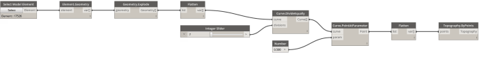
Simply click the select button and from the Revit view select the imported DWG instance. Dynamo will extract the contour lines after exploding the DWG geometry. To control the accuracy of the contour lines we shall divide the curves coming out from the explode command into arbitrary number of segments (controlled by the “Integer Slider” Node).
To create the surface we need points. The points can be generated from the segmented lines by getting the points at the middle of each segment.By clicking “Run” we get our desired Toposurface.
The Dynamo Workflow file can be downloaded from here

Revit does a pretty good job of creating topography from a DWG. Is there any significant benefit of going through Dynamo? Maybe I am missing something, but this looks like a round-about way to doing something that is really straight forward in Revit. No?
The idea is that you can control the accuracy of your toposurface using dynamo. If you use the traditional way (Create from Import) you will use it as it is, to increase the accuracy of the toposurface you will do it manually by inserting points and then adjusting the elevation, But using dynamo you can divide the contour lines to multi segments which will give you a more accurate surface presentation,
This is great! However, my surface is not showing up?! Nonetheless, excellent work! this is perfect for intricate terrain. Thanks for sharing!
Please check your Visibility/Graphics settings